Garfield County, Bryce Canyon National Park, and Grand Staircase-Escalante National Monument
Garfield County
We headed further south to Panguitch in Garfield County so that we could visit nearby Bryce Canyon and the Grand Staircase-Escalante National Monument. We stayed at Paradise RV Campground, an affordable stay with basic accomodations. Panguitch is a Paiute Indian phrase for "big fish" where they caught fish in the nearby lake. There are many old pioneer houses from the late 1800s here, built of brick from a brick factory that was here. Panguitch is the largest town in the county. The downtown has several quaint shops in old period buildings. Nearby are many scenic byways such as Scenic Byway 143 (with Panguitch Lake, Dixie National Forest, and Cedar Breaks National Monument), 83 (to Zion National Park), and 12 (which offers tremendous views of Red Canyon and is on the way to Bryce Canyon National Park and Grand Staircase-Escalante National Monument. The colors of the trees in the nearby Dixie National Forest are just now changing to orange, yellow, and fiery red. Further south is historic Cedar City, Parowan, and Brian Head, a winter skiing resort area. Due to the high elevation (over 10,000 feet in the Cedar Breaks area), it can snow at any time of the year.
| Bryce Canyon National Park | 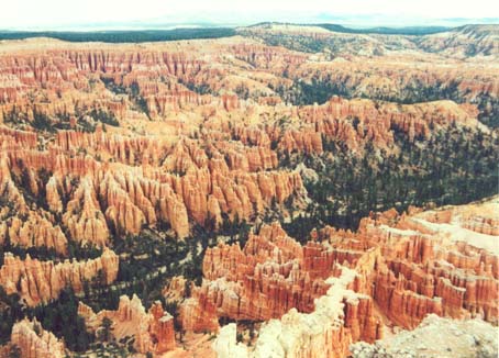 |
This was our next stop. Bryce Canyon is a fantasyland of colorful, delicately carved spires that can be viewed from overlooks all along the rim. There are trails leading down into the maze of colored spires. The odd-shaped spires are called "hoo-doos". Indians thought the spires were people turned to stone. There are brown, yellow, red and lavender hues to the limestone that forms all the formations. We stopped at all of the overlooks to take photos. Names include Sunrise Point, Sunset Point, Rainbow Point, Bryce Point, and Inspiration Point (my favorite). Ancient bristle cone pines in the area are up to 1,200 years old. The rock formations date back 50-60 billion years. From the main entrance, it is best to drive straight through the park to the end and come back so that all scenic stops are easy right turns. You can see far into the distance, all the way to Lake Powell on a clear day, due to the clean air here. If you are looking for an easy trail, take the hike from Sunrise Point to Queen's Garden, about 1.5 miles. There are longer trails which include overnight backcountry campsites along the bottom of the canyon. The park is named after Ebenezer Bryce, the first settler in the area. Ebenezer, whose cattle grazed in the maze-like stream beds of the canyon, declared it was "a hell of a place to lose a cow". The American Indian name for the place translates into "red rocks standing like men in a bowl-shaped canyon".
| Red Canyon | 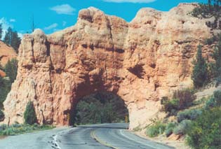 |
We next took Scenic Byway 12 to Red Canyon (sometimes referred to as "Little Bryce") which is a short distance outside of Panguitch. It has vivid red and pink colored cliffs, spires, and rock tunnels. From talking to Havard Heaton, with the U.S. Department of Agriculture Forest Service, he gave me an excellant overview of all the good trails to hike while in the area. The must see trails include the Castle Bridge, Cassidy, and Losee Canyon (where it meets with Casto Canyon Road). All of the trails start a short distance from the Visitor's Center. Sections of the Cassidy Trail were believed to have been used by Butch Cassidy, the old West outlaw. You may find additional information about Red Canyon here. We then drove on through the old towns ot Tropic (where Ebenezer Bryce settled), Henrieville, and Escalante (originally called Potato Valley for the wild potatoes that grew there).
Grand Staircase-Escalante National Monument
Created in 1996, this huge 1.7 million acre area contains rare rock formations, high multi-colored sandstone cliffs, messas, and ancient Anasazi Indian ruins, to name a few features. The cliffs rise upwards to over 6,000 feet in places exposing over three billion years of exposed rock. The majority of this land is undeveloped due to its' rustic features. Views are many along the road. If you want to spend a week in remote solitude, this is the place. We drove along Scenic Byway 12 at the top section. We stopped to view Powell's Peak, named after John Wesley Powell, who explored the Colorado River area throughout Utah and Arizona in the 1860s. At one section, there is a steep 12 percent grade. At mile marker 52, we stopped to view ancient Indian storage places in the cliffs that the Indians stored their grainery supplies. One section, called Burning Hills, has underground coal fires which give the rocks their red color. You can feel the heat as it rises from the ground. There are numerous waterfalls and arches which are in the far sections of the monument. We then drove along a 44 mile gravel road called Hell's Backbone (it is an appropriate name) bordering the Monument. On the way back through the monument, a huge boulder (3 feet tall) had fell onto the road in the opposite lane. An RVer was taking a look at it. It had to be close to a thousand pounds. I wish I had taken a picture and that we had more time to spend here.. We saw some more deer. We are now seeing deer on a daily basis.
| Hell's Backbone Road | 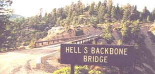 |
Hell's Backbone Road has been called "one of the most dramatic roads in the world". That is an understatement. Your heart leaps at every turn, seeing views deep into the ravens from both sides of the rough road in many places. The average speed we drove was 15 miles per hour. That was plenty fast along the narrow gravel and dirt road. There is a one-lane bridge along the way (built by the CCC). Besides the views along the ridges, you can see all types of interesting square shaped and round rocks in the area. Along the complete stretch of the road, we passed only three vehicles (several cows were meandering on the road though). The road was built as a passage for those traveling to the town of Boulder (the remote town was the last in the country to still receive mail via mule). The Anasazi Indian Village State Park is located here. About fifty percent of the buildings have been excavated so far, and date back over 900 years ago.
| Staying In The Ghost Town of Harrisburg | 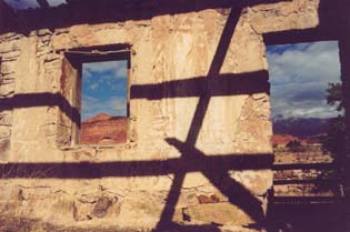 |
We headed to the St. George area, to stay at the Harrisburg RV Campground which is situated in an old ghost town by the same name. From here, we explored Zion National Park and the area. St. George is called Utah's Dixie for the warm climate. During the Civil War, cotton was grown here and a textile mill was in existence. Harrisburg was first settled in 1862. It hit its height in 1868, but in 1892 there were only a few families left and was deserted by the turn of the century. Four partial buildings are still standing (shown here).
Zion National Park
Zion was inspiring with it's massive multi-colored vertical cliffs and deep canyons, which the pioneers gave biblical names to such as Angels Landing, the Three Patriarchs (Abraham, Isaac, and Jacob), and the Great White Throne. We explored Scenic Drive but did not go through Zion-Mt. Carmel Highway. There is a long tunnel on this road that has a width restriction of 7½ feet. We exceeded that with the tow mirrors on our truck. Wider vehicles can go thru the tunnel but must be escorted and there is a ten dollar escort fee. On Scenic Drive, towering and vividly-colored cliffs line the road. It the centerpiece of the park. The walls of the canyon tower 2,000 to 3,000 feet. The Virgin River flows along the bottom of the canyon. This small river almost single-handedly carved the rock gorge of Zion Canyon. We drove to the end of Scenic Drive where we walked a mile-long path along the Virgin River to the beginning of the Narrows. The Narrows is a sixteen mile hike along the Virgin River as the canyon walls get taller and more and more narrow. About fourty percent of the time is spent hiking through water ankle to calf high with some spots even deeper. The reward for the hike is to glimpse some tremendous sheer canyon views. One of the lesser known side areas is the Kolob Canyon, which contains a free-standing arch (the world's largest) among tall sandstone cliffs. For more information about the area go here.
Next Week: Viva Las Vegas and on to Grand Canyon National Park
Questions? Want To Advertise Here? Contact Us
 |
 |